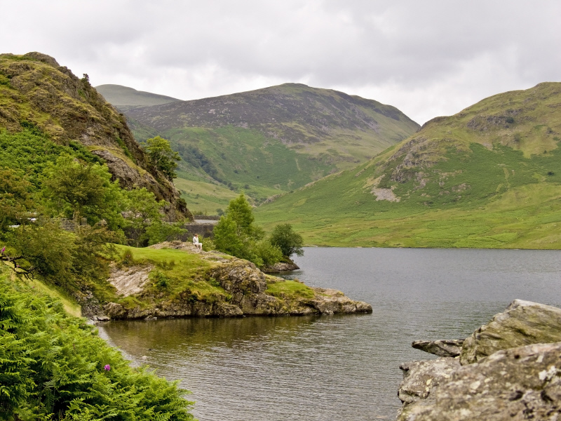
Lake District National Park
A mountainous region in North West England, the Lake District, also known as The Lakes is famous for its beautiful lakes and scenic forests. Lake District National Park is England’s largest national park and comprises most the Lake District except the Lake District Peninsulas lying in the south. Lake District National Park contains Scafell Pike, the highest mountain in England at nearly 1,000 meters (over 3,200 feet). The national park also contains England’s deepest lake, Wast Water, and England’s longest lake, Windermere.
Lake District National Park is the most visited national park in the England with nearly 16 million visitors each year. As in England’s other nine national parks there is no restriction on entry to the park along public routes, however access to farmed land is generally restricted to public footpaths. Unlike the national parks in the United States and many other countries, most of the land in Lake District National Park is in private ownership. The National Trust owns about a quarter of the land, the United Utilities owns eight percent and Lake District National Park Authority owns nearly four percent, with the remainder belonging to private owners.
England’s national parks are not wilderness areas, unlike national parks in other parts of the world. People live and work within the national parks and much of the land is farmed. There are roads, houses, shops and businesses within Lake District National Park. In fact, Lake District National Park is one of the most highly populated national parks in England. There are a handful of towns within this mountainous area including the four largest, Keswick, Windermere, Ambleside, and Bowness-on-Windermere. There are also a number of smaller villages in the area. Today, the economies of almost all are intimately linked with the national park’s tourism. While the lakes and mountains provide spectacular scenery, the farmland and villages which have been in this area for thousands of years, add to the natural beauty of this scenic region. However, the Lake District National Park was not approved as a natural World Heritage Site, because of these human activities, which adversely impacted the park’s UNESCO assessment.
The Lake District National Park has many glacial valleys containing numerous lakes which are what gave the area its name. The mountains of the Lake District National Park are rocky and moorlands are found at lower altitudes. The national park’s maritime climate provides for relatively moderate temperatures most of the year. Snow fall can occur between November and April at the higher elevations, however, hill fog is common year around and sunshine in the national park only averages between two and five hours per day, depending on the elevation and the time of the year.
Its location on England’s northwestern coast and its mountainous geography, all help to make Lake District National Park one of the dampest places in England. This provides an excellent home for the numerous mosses, ferns, lichen, and liverworts that thrive in the national park. Colonies of sundew and butterwort, two of the few carnivorous plants native to Britain, are also found in Lake District National Park. Deciduous woodland, including British and European native oak woodlands are found on the national park’s slopes, supplemented by introduced conifer plantations.
These woodlands provide habitats for the national park’s wildlife. The Lake District National Park, one of the few places in England where red squirrels are still found, is a major red squirrel sanctuary and has the largest red squirrel population in England. Since its introduction into England, the gray squirrel has displaced most of England’s indigenous red squirrel population, but not in the Lake District National Park. The osprey and red kite have both been re-introduced into the national park. Some of the other bird species found in the Lake District include the ring ouzel, buzzard, redstart, dipper, peregrine and raven.
The magnificent landscape of Lake District National Park has been influential on the lives and works of some of England’s best-known writers. Two of the famous authors who have lived in this magical place include William Wordsworth, one of England’s most famous poets, and Beatrix Potter, author of some of the world’s most loved children’s books. Some of the other poets and writers who have spent inspirational time in the Lake District include Samuel Coleridge, Thomas de Quincey, John Ruskin, Percy Bysshe Shelley, Sir Walter Scott, Nathaniel Hawthorne, Robert Southey, Arthur Hugh Clough, Henry Crabb Robinson, Thomas Carlyle, John Keats, Lord Tennyson, Matthew Arnold, Felicia Hemans, Arthur Ransome and Gerald Massey. The Lake District’s ties to famous artists and writers has done much for the national park’s cultural tourism, which is becoming an increasing portion of the area’s tourist industry. Tourism, as one might expect is the Lake District National Park’s major economic impact.
Lake District National Park – For More Information see the official site